1. What is Remote Sensing?
Remote sensing is the process of collecting data about an object or an area without physically being in contact with it. Instead of going to a place and observing it directly, remote sensing uses technology (like satellites, drones, or airplanes) to gather information from a distance.
In simpler terms, it’s like using a “fancy camera” to take pictures or measurements of things from far away, and then analyzing those images or data to learn more about the object or area.

2. How Does Remote Sensing Work?
Remote sensing works by detecting signals that are reflected or emitted by objects or surfaces. These signals are usually in the form of light, heat, or radio waves. Here’s a basic breakdown:
- Sensors on satellites, aircraft, or drones detect signals from the Earth’s surface.
- These sensors measure how much of the signal is reflected or emitted by the surface.
- The data is then processed and analyzed to make observations about the area, such as whether it’s a forest, a city, or a body of water.
Think of it like using a flashlight at night. The flashlight shines light on an object, and the light that bounces back helps you see and understand more about the object. In remote sensing, different types of energy (like light or heat) are sent out, and the reflected or emitted energy helps scientists understand what’s happening on the Earth’s surface.
3. Types of Remote Sensing
There are several types of remote sensing depending on what is being measured and how it’s being captured. The two main categories are:
A. Passive Remote Sensing
- In passive remote sensing, the sensors measure the energy that is naturally emitted or reflected by an object or area, usually from the sun.
- Example: Satellites or drones that use cameras or infrared sensors to capture sunlight reflected off forests, oceans, or cities.
Examples of passive remote sensing:
- Optical (Visible) Imaging: Captures visible light from the sun reflected off the Earth’s surface (like the photos you see from space).
- Thermal Imaging: Captures heat emitted by objects, like the heat from a building or the warmth of a forest.
B. Active Remote Sensing
- In active remote sensing, the sensor emits its own signal (like a radar or laser beam) and then measures the reflection of that signal from the Earth’s surface.
- Example: Radar (Radio Detection and Ranging) systems or LIDAR (Light Detection and Ranging) systems on satellites or aircraft.
Examples of active remote sensing:
- Radar: Sends out radio waves, and by measuring how those waves bounce back, it can tell how far objects are, even in the dark or through clouds.
- LIDAR: Sends out laser pulses and measures how long it takes for the pulse to return, creating detailed 3D maps of the surface.
4. Applications of Remote Sensing
Remote sensing has many uses across various fields, such as environmental monitoring, agriculture, urban planning, and disaster management. Here are some key examples:
A. Environmental Monitoring
- Remote sensing is used to monitor the health of the environment. For example:
- Forest monitoring: Detecting changes in forest cover, deforestation, or forest fires.
- Water quality: Monitoring the health of lakes, rivers, and oceans by measuring the amount of pollutants or algae.
- Air quality: Measuring the concentration of gases or pollutants in the atmosphere.
B. Agriculture
- Remote sensing helps farmers by:
- Crop monitoring: Checking the health of crops and detecting problems like pests, diseases, or drought.
- Precision farming: Using sensors to create maps that help farmers decide where to water, fertilize, or harvest crops.
- Soil moisture: Using satellites to measure how much water is in the soil, which helps with irrigation management.
C. Urban Planning
- Urban planners use remote sensing to understand:
- City growth: Monitoring how cities expand over time.
- Land use: Identifying different land types (residential, commercial, parks, etc.) using satellite images.
- Traffic monitoring: Analyzing traffic patterns and road conditions in cities.
D. Disaster Management
- Remote sensing helps in disaster response and recovery:
- Natural disasters: Satellites and drones can quickly capture images of areas affected by hurricanes, floods, or earthquakes.
- Damage assessment: After a disaster, remote sensing data can help assess the extent of the damage and plan for recovery.
- Monitoring volcanic eruptions or wildfires: Using heat detection to track temperature changes from these natural disasters.
E. Climate Change
- Scientists use remote sensing to track changes in the Earth’s climate, such as:
- Glacier retreat: Monitoring the shrinking of glaciers due to global warming.
- Sea level rise: Measuring changes in sea level and the extent of coastal flooding.
- Vegetation changes: Studying how vegetation is changing over time as the climate warms.
5. Common Tools Used in Remote Sensing
Here are some of the main tools and technologies used in remote sensing:
A. Satellites
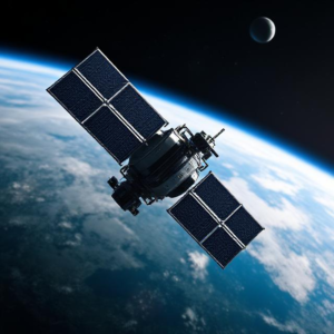
- Satellites are the most common tools for remote sensing. They orbit Earth and use sensors to capture images or data from space.
- Examples: Landsat satellites, Sentinel satellites, and weather satellites.
B. Drones (UAVs – Unmanned Aerial Vehicles)
- Drones are smaller and can fly lower to the ground, capturing high-resolution images and data of specific areas.
- Drones are used for detailed local mapping, agriculture, and disaster response.
C. Aircraft
- Manned or unmanned aircraft can carry remote sensing sensors (like cameras or radar) and fly at different altitudes to gather data over large areas.
D. Ground-Based Sensors
- Sometimes remote sensing is done from the ground level using sensors that measure specific features of the environment. For example, soil moisture sensors can help in agriculture.
6. Advantages of Remote Sensing
- Non-Invasive: You don’t have to touch or disturb the area being studied.
- Wide Area Coverage: Satellites and drones can cover large areas that would be hard or expensive to survey on foot.
- Real-Time Monitoring: Remote sensing allows for continuous or near-real-time monitoring of changes in the environment.
- Cost-Effective: It can be more cost-effective than sending people or equipment to physically collect data in difficult or remote locations.
7. Challenges in Remote Sensing
- Resolution Limitations: Sometimes, the images or data may not have enough detail (resolution), making it hard to identify small objects.
- Weather Conditions: Clouds, rain, or snow can interfere with sensors, especially optical cameras.
- Data Processing: The massive amount of data generated by remote sensing tools can be challenging to analyze and interpret.
Summary:
- Remote sensing is the technology that allows us to collect data from a distance without direct contact, usually using satellites, drones, or aircraft.
- It works by detecting energy reflected or emitted by objects on Earth (like light, heat, or radio waves) and then analyzing this data to understand various features of the environment.
- It’s used in many areas like environmental monitoring, agriculture, disaster management, and climate studies.
- Remote sensing gives us a way to observe and measure things from afar, making it easier and more efficient to monitor large areas and gather important information.
Keywords: Remote Sensing, Electronics, Robotics
Keywords: Remote Sensing, Electronics, Robotics


