What is LiDAR?
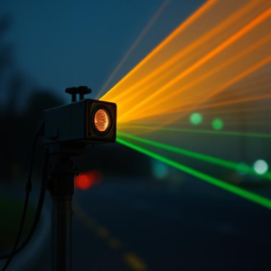
LiDAR stands for Light Detection and Ranging. It’s a technology that uses lasers to measure distances. Think of it like using light to “map” the world around you.
Here’s how it works:
- A LiDAR sensor sends out a pulse of light (a laser) toward an object or surface.
- The light bounces off that surface and returns to the sensor.
- The sensor measures how long it took for the light to come back.
- From that time, it can figure out how far away the object is.
By sending out thousands or millions of these light pulses per second, a LiDAR sensor can create a detailed 3D map of the environment.
How Does It Work?
Imagine you’re shining a flashlight around. The LiDAR sensor does something similar, but it uses a laser and very precise timing. The speed of light is super fast, so by calculating how long it takes for the laser to travel to an object and back, the sensor can measure the distance to that object very accurately.
Applications of LiDAR:
- Autonomous Vehicles (Self-Driving Cars):
- How it works: LiDAR is one of the key sensors in self-driving cars. It helps these vehicles “see” their surroundings and understand the environment.
- Why it’s useful: The car uses LiDAR to detect objects like other cars, pedestrians, traffic signs, and road obstacles. This 3D map allows the car to navigate safely without human input.
- Mapping and Surveying:
- How it works: LiDAR can scan large areas like forests, mountains, or cities to create detailed topographic maps.
- Why it’s useful: It’s faster and more accurate than traditional surveying methods. For example, LiDAR can be used to measure the height of trees, find hidden structures, or map the landscape for construction projects.
- Archaeology:
- How it works: LiDAR can penetrate through dense vegetation like trees or jungles, making it easier to find hidden structures or ancient ruins.
- Why it’s useful: Archaeologists use LiDAR to discover buried buildings, roads, and other structures that are hidden beneath thick forests or overgrown areas.
- Environmental Monitoring:
- How it works: LiDAR is used to map forests, coastlines, and even glaciers to monitor changes in the environment over time.
- Why it’s useful: Scientists use this data to study changes in landforms, erosion, and vegetation, helping us understand the effects of climate change.
- Construction and Engineering:
- How it works: LiDAR helps create accurate 3D models of construction sites, roads, and bridges.
- Why it’s useful: It helps engineers and architects make precise designs, plan for construction, and monitor the progress of projects in real-time.
- Agriculture:
- How it works: Farmers use LiDAR to analyze soil properties, crop health, and field topography.
- Why it’s useful: It helps optimize irrigation, monitor crops, and manage farming practices more efficiently, leading to better crop yields and resource management.
Why is LiDAR Special?
- Accuracy: LiDAR can capture extremely precise measurements, which makes it great for tasks that require high detail, like creating 3D models or mapping environments.
- Speed: It can quickly collect data over large areas, making it much faster than traditional methods.
- Penetration: LiDAR can “see” through obstacles like trees or foliage, which is something regular cameras or radar can’t do.
In Short:
LiDAR is a powerful tool that uses laser light to measure distances and create detailed 3D maps of the world around us. It’s used in self-driving cars, mapping landscapes, archaeology, environmental studies, construction, and agriculture, making it a versatile technology in many industries.